
Important Weather Update
Please read the following HAZARDOUS WEATHER OUTLOOK issued at 5:01 am on April 1, 2020 AND COASTAL FLOOD ADVISORY issued at 8:27 am on April 1, 2020 from the National Oceanic and Atmospheric Administration (NOAA) / National Weather Service:
HAZARDOUS WEATHER OUTLOOK National Weather Service Baltimore MD/Washington DC 501 AM EDT Wed Apr 1 2020: Chesapeake Bay north of Pooles Island MD- Chesapeake Bay from Pooles Island to Sandy Point MD- Chesapeake Bay from Sandy Point to North Beach MD- Chesapeake Bay from North Beach to Drum Point MD- Chesapeake Bay from Drum Point MD to Smith Point VA- Tidal Potomac from Key Bridge to Indian Head MD- Tidal Potomac from Indian Head to Cobb Island MD- Tidal Potomac from Cobb Island MD to Smith Point VA- Patapsco River including Baltimore Harbor- Chester River to Queenstown MD-Eastern Bay- Choptank River to Cambridge MD and the Little Choptank River- Patuxent River to Broomes Island MD- Tangier Sound and the inland waters surrounding Bloodsworth Island-District of Columbia-Southern Baltimore-
Prince Georges- Anne Arundel-Charles-St. Marys-Calvert- Southeast Harford- Prince William/Manassas/Manassas Park-Fairfax- Arlington/Falls Church/Alexandria-Stafford-Spotsylvania- King George-
501 AM EDT Wed Apr 1 2020 This Hazardous Weather Outlook is for the Maryland portion of the Chesapeake Bay, Tidal Potomac River, and adjacent counties in central Maryland and northern Virginia as well as the District of Columbia.
.DAY ONE...Today and Tonight A Coastal Flood Warning is in effect for Saint Mary`s County Maryland this morning.
.DAYS TWO THROUGH SEVEN...Thursday through Tuesday No hazardous weather is expected at this time.
.SPOTTER INFORMATION STATEMENT... Spotter activation is not expected at this time.
COASTAL FLOOD ADVISORY National Weather Service Baltimore MD/Washington DC 827 AM EDT Wed Apr 1 2020/ Calvert- 827 AM EDT Wed Apr 1 2020: COASTAL FLOOD ADVISORY REMAINS IN EFFECT UNTIL NOON EDT TODAY...
* WHAT...Up to one half foot of inundation above ground level in low lying areas due to tidal flooding.
* WHERE...Shoreline in Calvert County.
* WHEN...Until noon EDT today, especially around the current high tide.
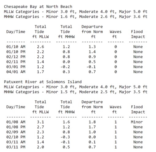
* IMPACTS...At 3.0 feet, parking lots near Charles Street in Solomons begin to flood, with several inches of water covering low-lying portions of Charles Street and Williams Street.
* ADDITIONAL DETAILS...Tides one and a half to two feet above normal. The next high tide at Chesapeake Beach is at 10:29 AM. High tide at Solomons Island is at 8:33 AM.
PRECAUTIONARY/PREPAREDNESS ACTIONS... If travel is required, allow extra time as some roads may be closed. Do not drive around barricades or through water of unknown depth. Take the necessary actions to protect flood-prone property.
Time of high total tides are approximate to the nearest hour.
Consider following NOAA on Facebook, visiting their website and creating a shortcut on your smartphone so you will have all the details necessary for this weather event and any future weather events.