
Important Weather Update

Please read information below regarding inclement weather conditions forecasted for our area.
Consider following NOAA on Facebook, visiting their website and creating a shortcut on your smartphone so you will have all the details necessary for this weather event and any future weather events.
Please read the following COASTAL FLOOD WATCH, COASTAL FLOOD ADVISORY, HURRICANE LOCAL STATEMENT, and TROPICAL STORM WARNING for our area from the National Oceanic and Atmospheric Administration (NOAA) / National Weather Service:
COASTAL FLOOD WATCH National Weather Service Baltimore MD/Washington DC 850 AM EDT Fri Sep 22 2023
...COASTAL FLOOD ADVISORY IN EFFECT FROM 5 AM TO NOON EDT SATURDAY...
...COASTAL FLOOD WATCH NOW IN EFFECT FROM SATURDAY AFTERNOON THROUGH LATE SATURDAY NIGHT...
* WHAT...For the Coastal Flood Advisory, up to one half foot of inundation above ground level expected in low lying areas due to tidal flooding. For the Coastal Flood Watch, up to one foot of inundation above ground level possible in low lying areas due to tidal flooding.
* WHERE...Shoreline in Calvert County.
* WHEN...For the Coastal Flood Advisory, from 5 AM to noon EDT Saturday, especially around the time of high tide. For the Coastal Flood Watch, from Saturday afternoon through late Saturday night, especially around the time of high tide.
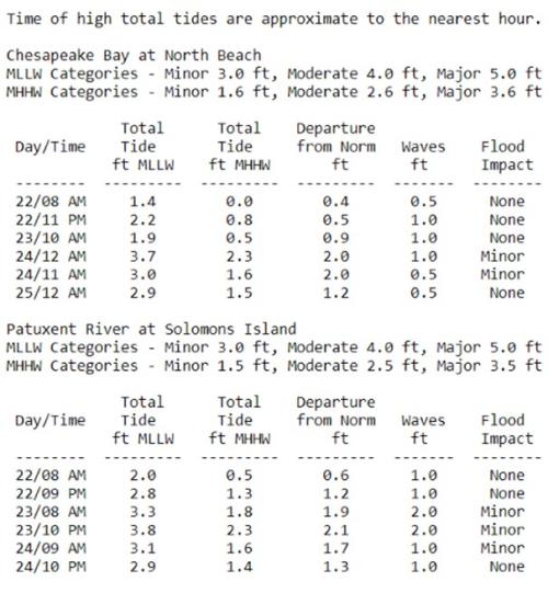
* IMPACTS...At 3.0 feet, water is expected to reach backyards near 9th Street in North Beach, and could approach 9th Street. At 3.5 feet, yards are flooded near Charles Street and Williams Street in Solomons. Nearby parking lots and the streets themselves are covered by more than a half foot of water.
* ADDITIONAL DETAILS...Tides two to two and a half feet above normal. The next high tide at Chesapeake Beach is at 9:26 AM and 10:23 PM. The next high tide at Solomons Island is at 8:27 PM and 8:30 AM.
PRECAUTIONARY/PREPAREDNESS ACTIONS...
If travel is required, allow extra time as some roads may be closed. Do not drive around barricades or through water of unknown depth. Take the necessary actions to protect flood-prone property.
COASTAL FLOOD ADVISORY National Weather Service Baltimore MD/Washington DC 850 AM EDT Fri Sep 22 2023
...COASTAL FLOOD ADVISORY IN EFFECT FROM 5 AM TO NOON EDT SATURDAY...
...COASTAL FLOOD WATCH NOW IN EFFECT FROM SATURDAY AFTERNOON THROUGH LATE SATURDAY NIGHT...
* WHAT...For the Coastal Flood Advisory, up to one half foot of inundation above ground level expected in low lying areas due to tidal flooding. For the Coastal Flood Watch, up to one foot of inundation above ground level possible in low lying areas due to tidal flooding.
* WHERE...Shoreline in Calvert County.
* WHEN...For the Coastal Flood Advisory, from 5 AM to noon EDT Saturday, especially around the time of high tide. For the Coastal Flood Watch, from Saturday afternoon through late Saturday night, especially around the time of high tide.
* IMPACTS...At 3.0 feet, water is expected to reach backyards near 9th Street in North Beach, and could approach 9th Street. At 3.5 feet, yards are flooded near Charles Street and Williams Street in Solomons. Nearby parking lots and the streets themselves are covered by more than a half foot of water.
* ADDITIONAL DETAILS...Tides two to two and a half feet above normal. The next high tide at Chesapeake Beach is at 9:26 AM and 10:23 PM. The next high tide at Solomons Island is at 8:27 PM and 8:30 AM.
PRECAUTIONARY/PREPAREDNESS ACTIONS... If travel is required, allow extra time as some roads may be closed. Do not drive around barricades or through water of unknown depth. Take the necessary actions to protect flood-prone property.
HURRICANE LOCAL STATEMENT Potential Tropical Cyclone Sixteen Local Statement Advisory Number 4
National Weather Service Baltimore MD/Washington DC 526 AM EDT Fri Sep 22 2023
This product covers Eastern West Virginia, Central and Western Maryland, Northern and Northwestern Virginia, and District of Columbia
**Tropical Storm Conditions Expected over Southern Maryland Tonight thorugh Early Sunday**
NEW INFORMATION ---------------
* CHANGES TO WATCHES AND WARNINGS: - None
* CURRENT WATCHES AND WARNINGS: - A Tropical Storm Warning is in effect for Calvert and St. Marys
* STORM INFORMATION: - About 590 miles south-southeast of Washington DC - 30.5N 75.0W - Storm Intensity 50 mph - Movement North or 360 degrees at 14 mph
SITUATION OVERVIEW ------------------
Potential Tropical Cyclone Sixteen will move north-northwestward toward the Mid-Atlantic Coast today before moving northward near the Mid-Atlantic Coast Saturday through Sunday. The main threat will be a storm surge with inundation around 2 to 3 feet most likely for locations along the western shore of the Chesapeake Bay as well as the shore of the tidal Potomac River. The highest water levels will be around times of high tide Saturday through Saturday night. Rainfall will most likely average between 2 to 4 inches with localized amounts up to 5 inches possible. This may result in isolated instances of flooding, especially for low lying and flood prone areas. The heaviest rain is most likely to occur Saturday into Saturday night. Tropical Storm force winds are most likely over southern Maryland and the nearby waters south of North Beach along the Chesapeake Bay and south of Cobb Island along the tidal Potomac River. However, gale-force winds are expected along the waters father north along the Chesapeake Bay as well as the tidal Potomac River. Gusty winds and a saturated ground may cause downed trees and power outages. While the severe weather threat is low, an isolated tornado cannot out be ruled across southern Maryland on Saturday afternoon and evening.
POTENTIAL IMPACTS -----------------
* WIND: Protect against hazardous wind having possible limited impacts. Potential impacts in this area include: - Damage to porches, awnings, carports, sheds, and unanchored mobile homes. Unsecured lightweight objects blown about. - Many large tree limbs broken off. A few trees snapped or uprooted, but with greater numbers in places where trees are shallow rooted. Some fences and roadway signs blown over. - A few roads impassable from debris, particularly within urban or heavily wooded places. Hazardous driving conditions on bridges and other elevated roadways. - Scattered power and communications outages.
* SURGE: Moderate tidal inundation is possible along the shore of the Chesapeake Bay and tidal Potomac River. - Localized inundation with storm surge flooding mainly along immediate shorelines and in low-lying spots, or in areas farther inland near where higher surge waters move ashore. - Sections of near-shore roads and parking lots become overspread with surge water. Driving conditions dangerous in places where surge water covers the road. - Moderate beach erosion. Heavy surf also breaching dunes, mainly in usually vulnerable locations. Strong rip currents. - Minor to locally moderate damage to marinas, docks, boardwalks, and piers. A few small craft broken away from moorings.
* FLOODING RAIN: Isolated instances of flooding are possible due to locally heavy rainfall. The best chance for flooding will be in low lying flood prone areas as well as urban locations. - Moderate rainfall flooding may prompt several evacuations and rescues. - Rivers and tributaries may quickly become swollen with swifter currents and overspill their banks in a few places, especially in usually vulnerable spots. Small streams, creeks, canals, arroyos, and ditches overflow. - Flood waters can enter some structures or weaken foundations. Several places may experience expanded areas of rapid inundation at underpasses, low-lying spots, and poor drainage areas. Some streets and parking lots take on moving water as storm drains and retention ponds overflow. Driving conditions become hazardous. Some road and bridge closures. Protect against locally hazardous rainfall flooding having possible limited impacts across southern Maryland.
* TORNADOES: Protect against a tornado event having possible limited impacts across southern Maryland. Potential impacts include: - The occurrence of isolated tornadoes can hinder the execution of emergency plans during tropical events. - A few places may experience tornado damage, along with power and communications disruptions. - Locations could realize roofs peeled off buildings, chimneys toppled, mobile homes pushed off foundations or overturned, large tree tops and branches snapped off, shallow-rooted trees knocked over, moving vehicles blown off roads, and small boats pulled from moorings.
PRECAUTIONARY/PREPAREDNESS ACTIONS ----------------------------------
Closely monitor weather.gov. NOAA Weather Radio or local news outlets for official storm information. Be ready to adapt to possible changes to the forecast. Ensure you have multiple ways to receive weather warnings. * ADDITIONAL SOURCES OF INFORMATION: - For information on appropriate preparations see ready.gov - For information on creating an emergency plan see getagameplan.org - For additional disaster preparedness information see redcross.org
NEXT UPDATE -----------
The next local statement will be issued by the National Weather Service in Baltimore MD/Washington DC around 11:15 AM, or sooner if conditions warrant.
TROPICAL STORM WARNING National Weather Service Baltimore MD/Washington DC 516 AM EDT Fri Sep 22 2023
...TROPICAL STORM WARNING REMAINS IN EFFECT...
* LOCATIONS AFFECTED - Calvert
* WIND
- LATEST LOCAL FORECAST: Below tropical storm force wind - Peak Wind Forecast: 20-30 mph with gusts to 50 mph
- THREAT TO LIFE AND PROPERTY THAT INCLUDES TYPICAL FORECAST UNCERTAINTY IN TRACK, SIZE AND INTENSITY: Potential for wind 39 to 57 mph - The wind threat has remained nearly steady from the previous assessment. - PLAN: Plan for hazardous wind of equivalent tropical storm force. - PREPARE: Efforts to protect property should now be underway. Prepare for limited wind damage. - ACT: Act now to complete preparations before the wind becomes hazardous.
- POTENTIAL IMPACTS: Limited - Damage to porches, awnings, carports, sheds, and unanchored mobile homes. Unsecured lightweight objects blown about. - Many large tree limbs broken off. A few trees snapped or uprooted, but with greater numbers in places where trees are shallow rooted. Some fences and roadway signs blown over. - A few roads impassable from debris, particularly within urban or heavily wooded places. Hazardous driving conditions on bridges and other elevated roadways. - Scattered power and communications outages.
* STORM SURGE
- LATEST LOCAL FORECAST: Localized storm surge possible - Peak Storm Surge Inundation: The potential for 1-3 feet above ground somewhere within surge prone areas - Window of concern: early Saturday morning until early Sunday morning
- THREAT TO LIFE AND PROPERTY THAT INCLUDES TYPICAL FORECAST UNCERTAINTY IN TRACK, SIZE AND INTENSITY: Potential for storm surge flooding greater than 1 foot above ground - The storm surge threat has remained nearly steady from the previous assessment. - PLAN: Plan for storm surge flooding greater than 1 foot above ground. - PREPARE: Complete preparations for storm surge flooding, especially in low-lying vulnerable areas, before conditions become unsafe. - ACT: Leave immediately if evacuation orders are given for your area.
- POTENTIAL IMPACTS: Limited - Localized inundation with storm surge flooding mainly along immediate shorelines and in low-lying spots, or in areas farther inland near where higher surge waters move ashore. - Sections of near-shore roads and parking lots become overspread with surge water. Driving conditions dangerous in places where surge water covers the road. - Moderate beach erosion. Heavy surf also breaching dunes, mainly in usually vulnerable locations. Strong rip currents. - Minor to locally moderate damage to marinas, docks, boardwalks, and piers. A few small craft broken away from moorings.
* FLOODING RAIN
- LATEST LOCAL FORECAST: - Peak Rainfall Amounts: 2-4 inches, with locally higher amounts
- THREAT TO LIFE AND PROPERTY THAT INCLUDES TYPICAL FORECAST UNCERTAINTY IN TRACK, SIZE AND INTENSITY: Potential for moderate flooding rain - The flooding rain threat has remained nearly steady from the previous assessment. - PLAN: Emergency plans should include the potential for moderate flooding from heavy rain. Evacuations and rescues are possible. - PREPARE: Consider protective actions if you are in an area vulnerable to flooding. - ACT: Heed any flood watches and warnings. Failure to take action may result in serious injury or loss of life.
- POTENTIAL IMPACTS: Significant - Moderate rainfall flooding may prompt several evacuations and rescues. - Rivers and tributaries may quickly become swollen with swifter currents and overspill their banks in a few places, especially in usually vulnerable spots. Small streams, creeks, canals, arroyos, and ditches overflow. - Flood waters can enter some structures or weaken foundations. Several places may experience expanded areas of rapid inundation at underpasses, low-lying spots, and poor drainage areas. Some streets and parking lots take on moving water as storm drains and retention ponds overflow. Driving conditions become hazardous. Some road and bridge closures.
* TORNADO
- LATEST LOCAL FORECAST: - Situation is unfavorable for tornadoes
- THREAT TO LIFE AND PROPERTY THAT INCLUDES TYPICAL FORECAST UNCERTAINTY IN TRACK, SIZE AND INTENSITY: Tornadoes not expected - The tornado threat has remained nearly steady from the previous assessment. - PLAN: Tornadoes are not expected. Showers and thunderstorms with gusty winds may still occur. - PREPARE: Little to no preparations needed to protect against tornadoes at this time. Keep informed of the latest tornado situation. - ACT: Listen for changes in the forecast.
- POTENTIAL IMPACTS: Little to None - Little to no potential impacts from tornadoes.
* FOR MORE INFORMATION: - http://ready.gov/hurricanes